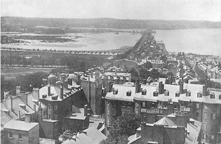
Filling The Back Bay
1820 -
1870

Pictured here is the view looking west
from the State House around 1830. The Mill Dam, shown here, extended out as
Beacon St. all the way to Brookline. The near in shoreline to its left was the
edge of the Public Garden. The Boston neighborhoods of the Back Bay, Kenmore
and much of the South End were uninhabitable salt marsh.
The
Commonwealth's threat to take this land under public health laws motivated
business and city government to agree on a plan to fill and create the 580
acres of the Back Bay in Boston. Nine train cars loads of gravel arrived every
45 minutes, day and night for nearly fifty years. This created the land that
Trinity Church and all of Copley Square now sits on.
Filled land is
unable to support large buildings. It requires a system of supporting
structures that connect the building to to rock. The heavier the building, the
greater the support structure needed. All of the buildings in Boston's Back Bay
are built with supports passing through fill to bedrock.
|


